YAO YU
yayu@ucsd.edu
Postdoc at Institute of Geophysics and Planetary Physics,
Scripps Institution of Oceanography
Research
A major tool in my work is satellite altimetry, especially the SWOT mission, which offers two key advantages: it provides global measurements of ocean surface height that demonstrate ocean dynamics across multiple spatial and temporal scales, and its multi-year (actually one year is already good enough ) mean fields reveal structures of the solid Earth, including the seafloor.

This animation shows how SWOT collect data over the state of Florida, which is rich with rivers, lakes, and wetlands. Globally, SWOT measures the height of water in the ocean and in lakes, rivers, and reservoirs on land.
@NASA.
Much of my effort goes into processing altimetry data to extract signals while reducing noise, depending on the scientific question at hand. I also do theoretical modeling to compliment observation work, explore machine learning applications in Earth sciences, and am currently learning numerical modeling.
A major challenge in physical oceanography is the limited understanding of small-scale dynamics and turbulence. I am interested in the processes that occur near the seafloor, which it intricate on its own. My past research projects/publications are listed on CV and Google Scholar.

Current Projects
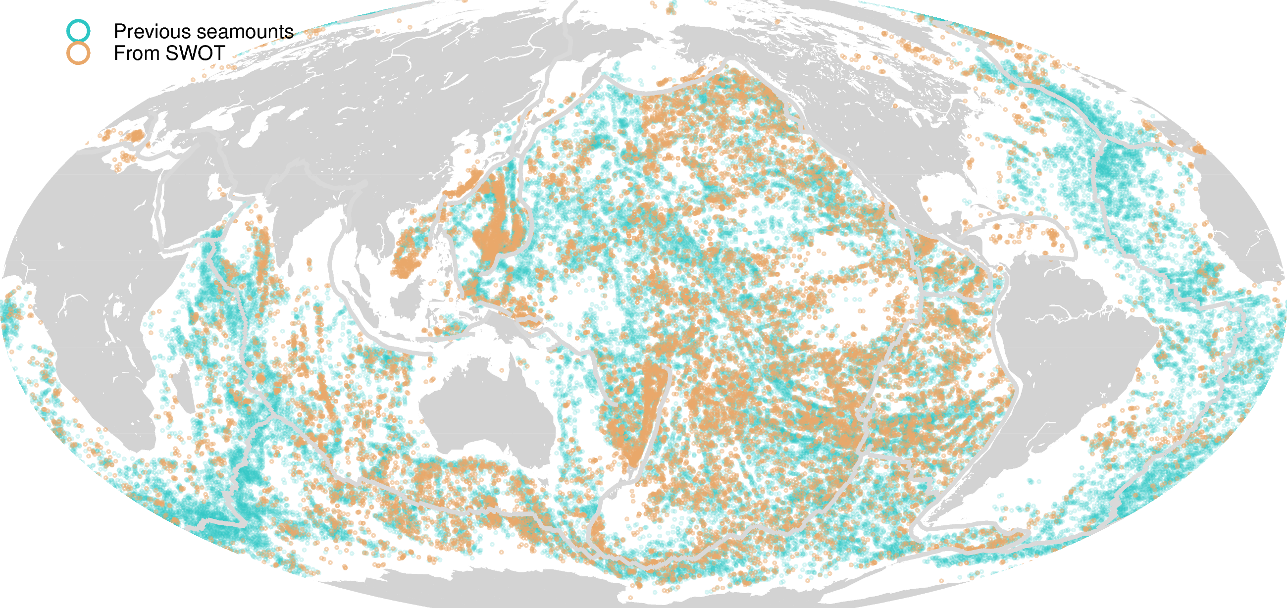
- I am handpicking small seamounts using the Vertical Gravity Gradient (VGG) map from SWOT.
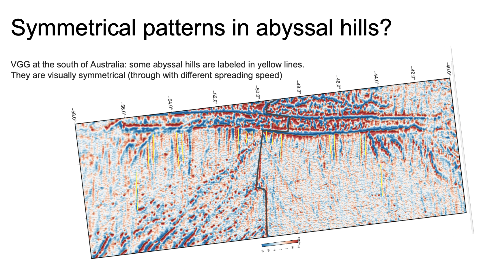
- Do abyssal hills exhibit periodicity and symmetrical patterns? Are the extremely long abyssal hills observed by SWOT real and what processes are responsible for their formation?
- What role do abyssal hills, the most abundant landform on Earth, play in shaping ocean dynamics?
- In search of Taylor columns using SWOT and PACE satellites
This work is going on with undergraduate student Martin Hawks. We found ~16,000 new seamounts with a height of ~1km from the SWOT gravity map, in addition to 43,000 known seamounts observed by ship soundings or traditional nadir altimetry. Global marine gravity products and kmz files can be accessed through: the topex ucsd site.
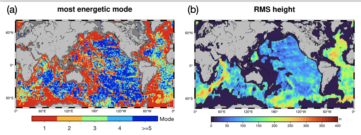
This figure is from a manuscript currently under review. It shows that the dominant mode of M2 internal tides (a) is strongly influenced by the height of abyssal hills (b). At fast-spreading ridges, where abyssal hills are low and narrow, high-mode internal tides are more likely to be generated. These tides tend to break locally, enhancing mixing near the generation site. In contrast, slow-spreading regions or areas with thick sediments tend to generate low-mode internal tides, which can propagate long distances and break near continental margins. Abyssal hills play a critical role in shaping internal tide dynamics. Abyssal hills matter!
When ocean currents flow past seamounts, they are diverted over and around the summit for the conservation of potential vorticity. In certain cases, these flows may produce a Taylor column, which is a closed circular eddy that can persist for long periods. See example: World's biggest iceberg spins in ocean trap.
While Taylor Columns have been extensively studied in theory and laboratory settings, they have rarely been observed in nature, despite offering a possible explanation for why seamounts often serve as marine habitats.
In this project, I’m using sea surface height data from the SWOT satellite to identify persistent eddies above seamounts, and confirming their presence using Chlorophyll-a and sea surface temperature data.